Climbing Tupungato

Tupungato, a formidable peak straddling the border between Argentina and Chile, stands tall at 6,570 meters, offering a challenging climb that attracts seasoned mountaineers. The ascent is not for the faint-hearted, with routes presenting a mix of steep slopes and rugged terrain. The mountain's relative remoteness adds an extra layer of difficulty, requiring climbers to be self-sufficient and well-prepared for a multi-day expedition. Weather can be unpredictable, with high winds and sudden temperature drops, so readiness for harsh conditions is essential.
Most climbers approach Tupungato from the Chilean side, utilizing the Valle de los Yaretas as the traditional base camp area. The approach involves navigating through valleys and high-altitude plateaus before tackling the more technical sections. The upper reaches of the mountain demand proficiency in glacier travel and crevasse navigation, with the final push to the summit often requiring crampons and ice axes. Those who reach the top are rewarded with panoramic views stretching across the Andes, a testament to the mountain's grandeur and the climber's perseverance.
Given the technical and logistical challenges of climbing Tupungato, it's no surprise that it remains less frequented compared to other Andean giants. The mountain's allure lies in its untouched nature and the solitude it offers, a rare opportunity for introspection amidst the vast wilderness. For those interested in organized expeditions, there are currently 9 guides offering climbs up this majestic peak, providing options for those who prefer a structured approach to their ascent.
Difficulty
- F: Easy (alpine grade 1)
When to go
- December to March
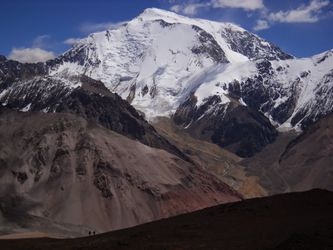
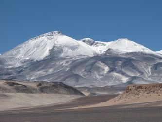
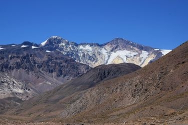
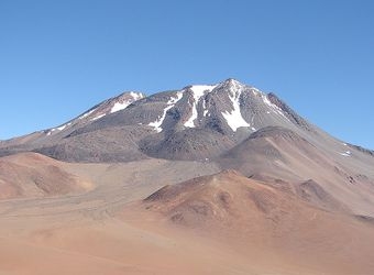
These are pictures taken while climbing Tupungato. They're shown here to give you an idea of what the route is like. You're welcome to share your own pictures of climbing Tupungato, to help the community of climbers. Picture here are either uploaded by members (their own, or creative commons pictures), or guides.
Guide links
Tupungato History
Climbing history of Tupungato
The history of Tupungato is intertwined with the exploration and mountaineering efforts that have shaped its legacy. Early summit attempts were fraught with challenges due to the mountain's formidable height and the treacherous conditions often encountered by climbers.
One of the notable early attempts to conquer Tupungato occurred in the late 19th century. In 1897, Matthias Zurbriggen, a Swiss guide, made a significant contribution to Andean mountaineering by achieving the first successful ascent of Aconcagua, and soon after, he set his sights on Tupungato. While Zurbriggen did not reach the summit of Tupungato, his efforts paved the way for future climbers by mapping routes and understanding the mountain's unique conditions.
Tupungato is located in a region steeped in cultural history, home to the indigenous Huarpe people long before European explorers arrived. Their presence and traditions have left an indelible mark on the area, adding a layer of cultural richness to the mountain's historical narrative.
Tupungato Links
useful websites, Groups and communities
Groups / links with more info on the Tupungato route.
These climbs are similar in length, difficulty, and elevation. Offering a similar level of challenge as the Tupungato climb.