Climbing Ampato


The mountain Ampato in Peru stands as a remarkable climb for those seeking both challenge and beauty. With an elevation of approximately 6,288 meters, it offers a route that, while not technically demanding, does test endurance and acclimatization skills. The ascent typically involves navigating through scree and snowfields, requiring a level of fitness and experience with high-altitude conditions. The weather on Ampato can be unpredictable, so it's essential to be prepared for sudden changes in temperature and wind conditions.
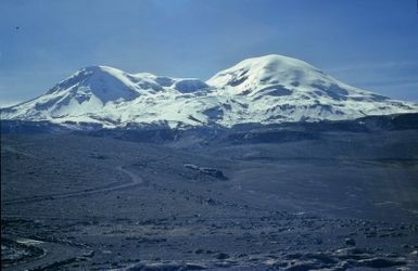
Reaching the summit of Ampato is a rewarding experience, with panoramic views stretching across the southern Peruvian Andes. The climb itself is a study in contrasts, as you traverse through barren volcanic landscapes juxtaposed with snow-capped peaks. The challenge lies not in technical climbing, but in the sheer elevation and the need to manage your pace and acclimatization. Those who have ascended Ampato often recount the tranquility and the isolation of the climb, making it a unique experience away from the more crowded peaks in the region.
If you're considering a climb, note that there are 4 guides offering expeditions up Ampato. While the route is straightforward for seasoned climbers, having local knowledge can enhance your understanding of the mountain's weather patterns and terrain. Whether you choose to go with a guide or independently, Ampato promises an adventure that tests your physical limits and rewards with breathtaking Andean vistas.
Table of contents
Difficulty
- F: Easy (alpine grade 1)
When to go
- May to August
These are pictures taken while climbing Ampato. They're shown here to give you an idea of what the route is like. You're welcome to share your own pictures of climbing Ampato, to help the community of climbers. Picture here are either uploaded by members (their own, or creative commons pictures), or guides.
Guide links
Ampato History
Climbing history of Ampato
The history of Ampato is intertwined with the ancient cultures that thrived in the region. The area around Ampato has been home to indigenous peoples, particularly the Inca, who left behind remarkable archaeological finds. The most famous of these is the discovery of the "Ice Maiden," a well-preserved Inca mummy found near the summit in 1995 by anthropologist Johan Reinhard. This discovery provided incredible insights into Inca rituals and beliefs.
While specific early summit attempts are not well-documented, the mountain likely held spiritual significance for the Inca, who might have approached or climbed it for ceremonial purposes. Modern climbing records suggest that Ampato was successfully summited in the mid-20th century by mountaineers exploring the volcanic peaks of the Andes.
 Base Camp
 High Camp
 Summit
From base camp you slowly move up decent but loose terrain to high-camp (optional). From there it's a few hundred more vertical meters to the glacier. You can either go up the glacier or to its left (when looking up the mountain), but the ground is pretty loose so most go up the glacier and down the scree. From where the glacier tops out you're still 200 meters from the summit. A route up to the left is typical, as straight ahead to the summit has a lot of loose scree. Otherwise you can go right to a false summit and follow the ridge to the summit - but that's a longer way.
Ampato Services
Gear rental, porters, guides, transport, internet, accommodation
Accommodation
Both base camp and high camp are simply locations for tents. There is no water at either. Bring water in from the stream you cross on the way to base camp beside the old house/farm.Guides
To be found in Arequipa.Transport
Private transport only. The route to base camp sees little traffic, but hitchhiking could be possible - if you're prepared to wait.Internet / Phone
There's no phone signal out here.Ampato access - getting there
How to get to Ampato
Ampato questions
What to know about climbing Ampato
Common questions people have about this trek, if yours isn’t here - add it to get an answer.
Ampato Links
useful websites, Groups and communities
Groups / links with more info on the Ampato route.
These climbs are similar in length, difficulty, and elevation. Offering a similar level of challenge as the Ampato climb.