Climbing Mount Rainier


Mount Rainier, a prominent stratovolcano located in the state of Washington, United States, stands as a formidable challenge for even seasoned climbers. With an elevation of 14,411 feet (4,392 meters), it is the tallest peak in the Cascade Range and a magnet for those seeking to test their skills on its icy slopes. The mountain's massive glaciers, including the well-known Emmons and Nisqually, demand technical proficiency and careful navigation. The climb is not to be underestimated, with routes like the Disappointment Cleaver offering a blend of rock, snow, and ice that require experience with roped travel and crevasse rescue techniques.
Climatic conditions on Mount Rainier can be unpredictable, adding an additional layer of complexity to any ascent. Weather systems rolling in from the Pacific Ocean can transform clear skies into storms rapidly, making it crucial for climbers to be prepared for sudden changes. The mountain's position also means that it is subject to high winds and heavy snowfall, particularly in the winter months. Even in summer, temperatures can plummet, and conditions can become severe. As such, it's essential for mountaineers to be well-acquainted with the mountain’s weather patterns and to plan climbs with flexibility in mind.
A successful summit attempt on Mount Rainier is a testament to a climber's endurance and technical skill. The mountain offers a variety of routes, each with its own set of challenges, from the heavily glaciated Liberty Ridge to the more accessible Paradise Glacier route. Each path requires a different approach, and climbers must be adept at assessing risk and making strategic decisions on the fly. For those interested in tackling this majestic peak, there are 17 guides available that offer expeditions and climbs, providing opportunities for further skill development and increasing the chances of a safe and rewarding ascent.
Difficulty
- AD: Fairly hard (alpine grade 3)
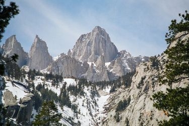
These are pictures taken while climbing Mount Rainier. They're shown here to give you an idea of what the route is like. You're welcome to share your own pictures of climbing Mount Rainier, to help the community of climbers. Picture here are either uploaded by members (their own, or creative commons pictures), or guides.
Guide links
Mount Rainier History
Climbing history of Mount Rainier
The history of Mount Rainier is deeply intertwined with the indigenous peoples of the Pacific Northwest, particularly the Yakama, Puyallup, Muckleshoot, and Nisqually tribes, who have long revered the mountain and its surrounding areas.
One of the earliest recorded summit attempts was in 1833 by Dr. William Fraser Tolmie, a Hudson's Bay Company employee. Although Tolmie did not reach the summit, his exploration marked the beginning of documented pursuits to conquer the peak. The first successful ascent was accomplished on August 17, 1870, by Hazard Stevens and Philemon Beecher Van Trump. Their expedition was guided by information from local indigenous peoples, who provided crucial knowledge about the terrain.
Mount Rainier was designated as a National Park in 1899, becoming the fifth national park in the United States. This recognition helped preserve the area and opened it up for further exploration and study, establishing it as a significant site for mountaineers and nature enthusiasts alike.
These climbs are similar in length, difficulty, and elevation. Offering a similar level of challenge as the Mount Rainier climb.