Climbing Mount Katahdin

Mount Katahdin, the highest peak in Maine, stands at an impressive 5,267 feet and offers a challenging and rewarding climb for experienced mountaineers. Located in Baxter State Park, it marks the northern terminus of the Appalachian Trail and is renowned for its rugged beauty and steep ascents. The most popular route, the Hunt Trail, requires careful navigation over large boulders and exposed ridges, particularly near the notorious Knife Edge, a narrow, rocky ridge that demands respect and a steady foot. The varied terrain, from dense forests to alpine zones, ensures that the climb is as technically engaging as it is awe-inspiring.
Conditions on Mount Katahdin can change rapidly, with weather patterns often bringing dense fog, high winds, and sudden temperature drops. These factors contribute to the mountain's reputation for being a challenging climb, even in the summer months. Winter ascents are reserved for the most seasoned climbers, as the mountain is prone to icy conditions, deep snow, and extreme cold. Planning is crucial; understanding weather patterns and carrying appropriate gear is essential for a safe and successful climb. The mountain's remote location also means that you're likely to encounter fewer crowds, offering a more solitary and introspective climbing experience.
For those considering an ascent, it's worth noting that Mount Katahdin is not just a physical challenge, but a journey through raw, untamed wilderness. The climb offers unparalleled views of the surrounding mountains and valleys, rewarding every ounce of effort put into the ascent. It's a mountain that demands respect and preparation, but for those who are ready, it offers one of the most memorable climbs in the northeastern United States. There are 2 guides available for those seeking professional support, but many experienced climbers relish the opportunity to tackle the mountain independently.
Difficulty
- PD: Not very hard (alpine grade 2)
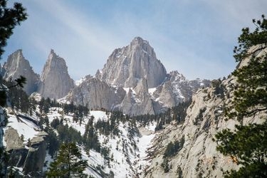
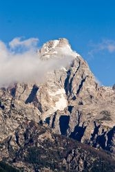
These are pictures taken while climbing Mount Katahdin. They're shown here to give you an idea of what the route is like. You're welcome to share your own pictures of climbing Mount Katahdin, to help the community of climbers. Picture here are either uploaded by members (their own, or creative commons pictures), or guides.
Guide links
Mount Katahdin History
Climbing history of Mount Katahdin
The history of Mount Katahdin is rich with early exploration and the cultural significance it holds for the indigenous people of Maine. The Penobscot Nation, who have lived in the region for thousands of years, regard Katahdin as a sacred place, calling it "Kette-Adene," which means "The Greatest Mountain."
One of the earliest recorded summit attempts was in 1804 by Charles Turner, Jr., a surveyor who ascended the mountain as part of his work in mapping the area. Turner's account marked the beginning of documented climbs and sparked interest in the mountain among explorers and adventurers.
In the 19th century, Henry David Thoreau famously attempted to climb Katahdin during his travels in Maine, describing his journey in "The Maine Woods." Thoreau's reflections on the mountain highlighted its wild beauty and the formidable challenges posed by its rugged terrain.
Throughout the late 1800s and early 1900s, Katahdin attracted increasing numbers of climbers and nature enthusiasts, eventually leading to the establishment of Baxter State Park in 1931, which preserved the mountain and its surrounding wilderness for future generations to explore and enjoy.
These climbs are similar in length, difficulty, and elevation. Offering a similar level of challenge as the Mount Katahdin climb.